Air masses
An air mass is a large volume of air whose physical properties (temperature and humidity) are uniform in the horizontal plane.
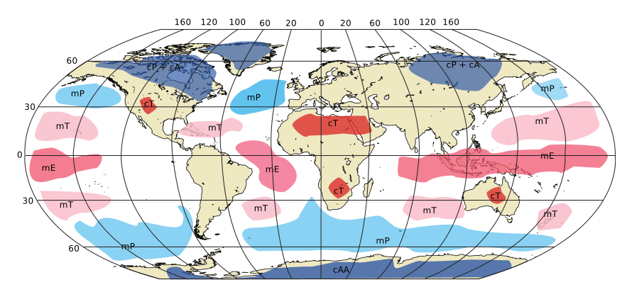
Classification
Air masses are classified using a three-letter system according to their moisture content, their region of origin, and their temperature relative to the surface.
1. Moisture Content (First Letter)
- m (Maritime): Moist. Oceanic origin.
- c (Continental): Dry. Land origin.
2. Region of Origin / Temperature (Second Letter)
- A (Arctic): Arctic. Very cold.
- P (Polar): Polar. Cold (origin in high latitudes, not necessarily at the poles).
- T (Tropical): Tropical. Warm.
- E (Equatorial): Equatorial. Very warm (does not typically affect Europe).
3. Relative Temperature (Third Letter)
- k (cold/kalt): The air mass is colder than the surface over which it moves.
- Warmed from below $\rightarrow$ Instability.
- Cumuliform clouds, showers, good visibility (except in precipitation).
- w (warm): The air mass is warmer than the surface over which it moves.
- Cooled from below $\rightarrow$ Stability.
- Stratiform clouds, fog, drizzle, poor visibility. Temperature inversions.
Air Masses Affecting Europe
| Air Mass | Code | Origin | Typical Characteristics |
|---|---|---|---|
| Arctic Maritime | mAc | Polar caps / Arctic | Very cold. Becomes unstable moving south over the warm sea. Snow/Showers. |
| Polar Maritime | mPc | North Atlantic (Greenland/Canada) | Cold and moist. The most common in Western Europe. Unstable (warmed from below). Showers, Cu/Cb. |
| Polar Continental | cPc | Siberia / Russia (Winter) | Very cold and dry. Stable. "The Beast from the East". |
| Tropical Maritime | mTw | Azores High | Warm and moist. Stable (cooled from below). Stratiform clouds, drizzle. |
| Tropical Continental | cTw | North Africa / Turkey | Warm and dry. Stable. Heat waves in summer. |
Key Concepts
- Stability at Source: All air masses are stable in their region of origin (usually high-pressure zones).
- Modification: Air masses modify their properties as they move.
- Cold Air over Warm Surface: Instability (convection). Example: Polar Air moving towards the equator.
- Warm Air over Cold Surface: Stability (inversion). Example: Tropical Air moving towards the poles.
- Orographic Effect: When an unstable air mass (like mPc) hits mountains, the forced ascent intensifies the instability, creating more developed clouds, heavier precipitation, and a higher risk of icing on the windward side.
- Seasonal Shift: In the northern hemisphere, frontal systems and air masses shift to the North in summer (following the sun) and to the South in winter.
Polar Front Depressions
The Polar Front separates Polar air (cold) from Tropical air (warm). In a typical North Atlantic depression:
- Warm Sector: Tropical Air (mTw).
- Ahead and Behind the depression: Polar Air (mPc).