Global Navigation Satellite Systems (GNSS) for Aviation
GNSS is a general term encompassing satellite navigation systems that provide autonomous geospatial positioning with global coverage.
Main Systems
There are four main recognized GNSS systems:
- NAVSTAR GPS (USA): Operational.
- GLONASS (Russia): Operational.
- Galileo (Europe): Operational.
- BeiDou (China): Operational.
Interoperability
- System Level: GPS and GLONASS are interoperable at the system level. They have different frequencies and reference frames (WGS-84 vs PZ-90), so their signals are not directly compatible, but the receiver can process both solutions independently and combine them.
- Signal Level: Galileo and GPS have certain frequencies that are interoperable at the signal level.
NAVSTAR GPS
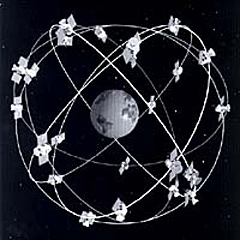
The GPS system consists of three segments:
- Space Segment:
- Nominal constellation of 24 satellites (technical minimum).
- Orbit in 6 orbital planes at an altitude of approximately 20,200 km.
- Orbital period of 12 hours.
- Control Segment:
- Ground monitoring and control stations.
- Maintain constellation health, correct atomic clocks, and update ephemerides.
- User Segment:
- GPS receivers (aircraft, mobile devices, etc.).
Operating Principle

The receiver calculates its position via trilateration by measuring the time it takes for the signal to travel from the satellite to the receiver (Pseudorange).
- 3 Satellites: 2D Position (Latitude, Longitude) + Time (if altitude is known).
- 4 Satellites: 3D Position (Latitude, Longitude, Altitude) + Time.
Frequencies and Services
Satellites transmit in the UHF band (L-Band):
- L1 (1575.42 MHz):
- Carries the C/A (Coarse Acquisition) code and the P (Precision) code.
- Provides the SPS (Standard Positioning Service) for civil use.
- L2 (1227.60 MHz):
- Carries only the P code.
- Together with L1, provides the PPS (Precise Positioning Service) for authorized users (military).
- Using two frequencies allows correcting ionospheric errors.
Navigation Message
Each satellite transmits:
- Almanac: Approximate orbital data for the entire constellation.
- Ephemeris: Precise orbital data for the specific satellite.
- Clock Correction: Status of the satellite's atomic clock.
- Ionospheric Model: To correct delays in single-frequency receivers.
System Errors
Error Sources
- Ionospheric Delay: This is the most significant error. The ionosphere slows down the signal. It is mitigated with mathematical models or dual-frequency receivers.
- Satellite Clock Errors: Although they use atomic clocks, small drifts exist.
- Ephemeris Errors: Difference between the actual and expected position of the satellite.
- Multipath: Reflection of the signal off surfaces (buildings, terrain) before reaching the antenna.
- Receiver Noise: Internal equipment errors.
Dilution of Precision (DOP)
Satellite geometry affects the accuracy of the calculated position.
- GDOP (Geometric Dilution of Precision): Measure of geometry quality.
- PDOP (Position Dilution of Precision): Dilution in 3D position.
- Low Value = Better Accuracy.
- Ideal Geometry: One satellite directly overhead (zenith) and three on the horizon separated by 120°.
- Poor Geometry: Satellites clustered very close to each other.
Total Error = UERE (User Equivalent Range Error) × GDOP
Integrity (RAIM)
RAIM (Receiver Autonomous Integrity Monitoring) is a technique where the receiver uses "extra" satellites to verify the integrity of the navigation solution.
- Fault Detection (FD): Requires minimum 5 satellites. Detects if a satellite is failing but cannot identify which one.
- Fault Detection and Exclusion (FDE): Requires minimum 6 satellites. Detects and excludes the faulty satellite, allowing navigation to continue.
- If barometric aiding (pressure altitude) is available, one less satellite is required (4 for FD, 5 for FDE).